


Hayes | Kisipikamawi River
Apiht Sipi
Designated
Story Map
Each Heritage River Story Map displays various visual representations of geospatial data in combination with text, photos, videos and external links.
Natural Heritage
The Hayes River route, which includes 43 km of the Nelson River, the 67 km-long Echimamish River and the entire 480 km of the Hayes, begins its course at the north end of Lake Winnipeg and flows northeast to Hudson Bay. Flowing through pristine boreal forests of the Canadian Shield at its upper reaches, and soggy muskeg lowlands in its lower reaches close to Hudson Bay, the Hayes provides travelers with a unique perspective of both landscapes. Travelling downstream, one sees dense spruce forests gradually replaced by a mosaic of stunted black spruce and tamarack interspersed with bogs, and finally the treeless tundra at the coast.
Remote stretches of white-water, large lake systems, deep valleys, gorges, and the northern boreal forest characterize the southern, upper reaches of the river. At its northern reaches, the Hayes flows through a flat terrain of muskeg, lakes, streams and bogs, cutting steep banks up to 30 metres high into the thick marine clay of Hudson Bay. Tidal flats extend seaward for several kilometres at the river’s mouth.
Wildlife along the river includes black bears, caribou, moose, wolverine, lake sturgeon, and eagles. In the lower reaches, seals surface in the river, brook trout spawn, and polar bears give birth in dens along the Hudson Bay coast.
Cultural Heritage
The Hayes River has provided transportation, livelihoods, and resources to Ininiwak / Cree people for thousands of years. Now part of Treaty 5 territory, the river corridor continues to be home to Ininiw communities including Norway House, Bunibonibee, Manto Sipi, Shamattawa, Fox Lake and York Factory.
There are a number of archaeological sites along the riverbank that demonstrate the river’s importance long before the arrival of European settlers. Numerous burials and pictographs are further testimony to the many years of human culture along the river. The Painted Stone Portage continues to be a sacred place of worship.
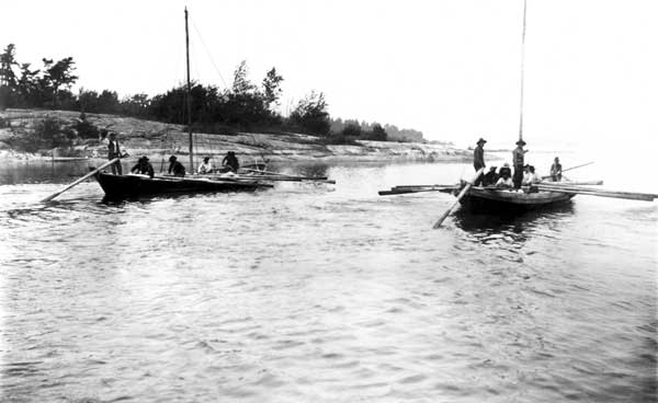
In the mid 1600’s, the arrival of fur traders and “coureur de bois” heralded a new way of life on the Hayes River and throughout western Canada. York Factory was the Hudson’s Bay Company’s principal fur trade depot and its centre of operations for over 200 years. Although it was closed in 1957, and the local community was relocated inland, the Depot building still sits near the mouth of the Hayes River, now a National Historic Site.
Today the Ininiw descendants of the original inhabitants of the area live in this region and regularly access the river system for harvesting, recreation, and cultural purposes. In 2010, members of York Factory First Nation and Fox Lake Cree Nation returned to York Factory to commemorate 100 years since their ancestors signed treaty in 1910.
Recreational Heritage
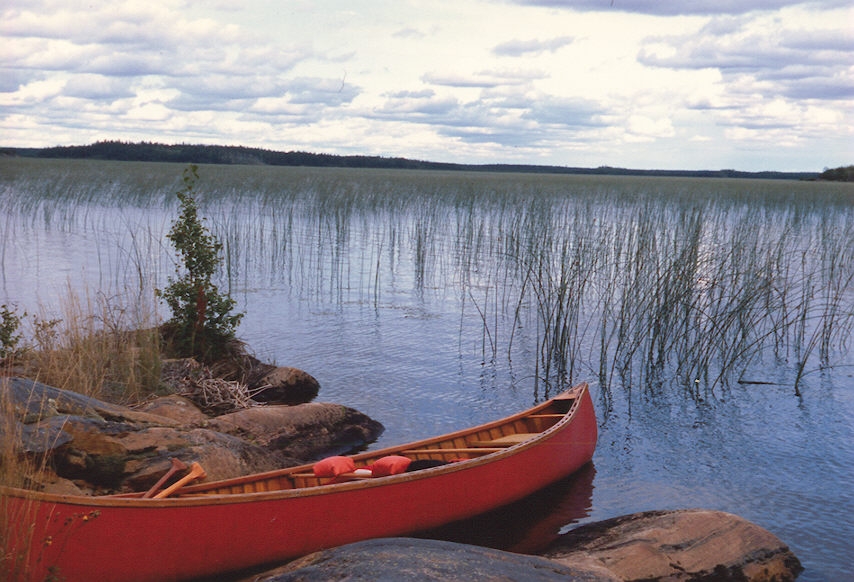
The Hayes River provides outstanding wilderness opportunities. Nine lakes and the connecting river offer unparalleled wilderness canoeing and kayaking, alternating between white-water and flat-water paddling.
One trip that encompasses the full downstream route begins at Norway House and ends at York Factory on Hudson Bay, approximately 600 km in total, but paddlers can also start their trip at Oxford House, for a 380 km trip. Norway House to Oxford House takes approximately eight to 10 days to paddle, and Oxford House to York Factory takes 14 to 18 days. There are over 90 undesignated campsites along the route, approximately 45 sets of rapids and falls, many of which are runnable by experienced white-water canoeists, and approximately 27 portages, some of which are pullovers or can be lined. However, paddlers must be aware that travelling the full route starting on the Nelson River and ending on the Hayes now carries a risk of spreading zebra mussels, an aquatic invasive species (AIS), from the Nelson to the Hayes. In order to reduce the risk of spreading zebra mussels, paddlers must follow the AIS Regulation under The Water Protection Act, and boaters must take precautions after exiting the Nelson River. Information on how to properly decontaminate your watercraft and equipment can be found online here.
Additional information on river access, accommodation, services and maps is available from Manitoba Conservation and Climate.
To preserve cultural sites along the river, visitors are encouraged to leave all sites undisturbed and to avoid touching or splashing pictographs.
Fun Fact
Robinson Falls is one of the more well-known sites along the river, featuring five sets of waterfalls forcing a violent torrent of water through massive granite formations.
River Managers
The Hayes River is managed by Manitoba Conservation and Climate. The management plan for the river is available online, as well as the ten-year monitoring report.
Discover More
Designation
The Hayes River was the main route from York Factory on Hudson Bay to the interior of western Canada for fur traders, settlers, and explorers from 1670 until 1870, and was an important trade, transportation, and communication route for Indigenous Peoples long before then. The longest naturally flowing river in Manitoba, today the river is a hub for outstanding recreational opportunities.
The 600-km long Hayes River historic fur trade route consisting of the Nelson River, the Echimamish River and the Hayes River, was designated to the Canadian Heritage Rivers System in 2006 for its outstanding natural and cultural heritage and its supporting recreational values.
Resources
| title | type | file |
|---|---|---|
| Hayes River Monitoring Report 2006 - 2016 Archived / archive en anglais seulement | Decadal Monitoring Reports | PDF of Hayes River Monitoring Report 2006 - 2016 |
This page has been archived on the Web
Information identified as archived is provided for reference, research or recordkeeping purposes. It is not subject to the Government of Canada Web Standards and has not been altered or updated since it was archived. Please contact us to request a format other than those available.
Plaque Text
The Canadian Heritage River plaques offer a brief glimpse into why a river has been designated to the System. They are often located nearby one of its historically significant locations, and highlight some of the most important natural, cultural and recreational values of the river.
Hayes River Plaque Text
THE HAYES RIVER Historic Fur Trade Route - The Hayes River has a prominent role in the history and development of Canada. This 600 km route along the Hayes, Echimamish and Nelson rivers was the central transportation artery for the fur trade in the 17th, 18th and 19th centuries. In arduous expeditions by canoe and York boat, the “tripmen” of the Hayes transported furs and supplies between York Factory, on the Hudson Bay coast, and the Canadian interior. This brought a new way of life to the First Nation peoples of western Canada. Today, the river remains an important transportation route and provider of food, water and spiritual renewal. As a Canadian Heritage River, the Hayes’ rich history and pristine natural beauty will be honoured for generations to come.